Try this descent while getting high on a fourteener
You can see it from the trail. A white cleft that drops directly off of Torreys Peak.
It draws the eye in a sinuous line, plunging off the summit, a throat-wrenching vertical elevator that spills into a large snow-filled basin. It’s steep, and it’s scary, and you can’t help but want to ride it, even though it looks as if a fall would send you tumbling to your death.
The Dead Dog Coulior is a Colorado classic. And, although it is steep, the descent is well within the reach of solid skiers and snowboarders. Advanced intermediates should be able to swallow this one, while for those who have spent a bit more time on the hill — the experts — the line is the stuff that dreams are made of.
The best part of doing the Dog is the access. Bakerville sits on the east side of I-70’s Eisenhower Tunnel. The mining hamlet has dwindled to a few scrappy residents who hold on during the harsh winters. You can’t tell that this place used to be crowded, but the old mining tailings hint at boom-time days.
Bakerville provides the jumping off point for accessing two of Colorado’s fourteeners — Grays and Torreys. Because of this, the rugged dirt road that climbs out of Bakerville is well traveled, although a high-clearance vehicle will serve you well.
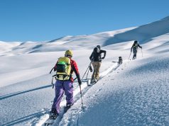
The popularity of bagging Colorado’s 14,000-foot peaks, coupled with the ease of access and proximity to the Front Range, means that you probably won’t be the only group in the parking lot. But that’s OK, as the Forest Service has put a virtual highway to the summit of Gray’s to accommodate the latter day rush of peak baggers. The going is fast and smooth, attributes that will be appreciated by anyone with a pair of skis or snowboard on their back. The trail also offers the perfect vantage point from which to scope your descent.
Take your time and memorize the entrance to the chute.
It’s the only technical, exposed section of the run. Halfway up the northeast face of Gray’s, it’s possible to follow several scree-lined trails that access the saddle between that summit and Torreys, your destination. From there the most difficult part of the climb — a steep hump up the flank of 14,267-ft. Torreys awaits.
The summit of Torreys is one of the best in Colorado. It’s a true high point, not just a high spot on a ridge, and it’s smack dab on the Continental Divide. Views stretch deep into the 10-Mile Range and east, all the way to Kansas. But while the views are spectacular, the skiing and boarding is even better: Dead Dog Coulior usually holds snow well into July.
“This is one of the best lines for those who want to notch up a fourteener and do a classic ski descent,” says Will Spilo.
He should know. Spilo spends his springs heli-guiding in Alaska and his summers working a similar gig in Chile.
With
first descents in both South America and Alaska to his name, Spilo says
that Colorado’s Dead Dog remains one of his favorite lines.
“The
access is easy, the hike can be done in four hours, and you can be back
at your car drinking beer by noon on a good day,” says Spilo. “It’s the
perfect spring line.”
Still,
Spilo cautions that while the proximity of Torreys to Interstate 70
makes the Dead Dog an easy line to bag, those who head up the mountain
should be prepared. Start early to avoid afternoon avalanche danger,
when wet slides caused by a warming snowpack are risky on steeper
terrain. Take extra clothing and sunscreen. And don’t be afraid to back
off the line if you think it’s out of your league.
“The
basin between Grays and Torreys is a great second option if you don’t
feel up to doing the Dead Dog” says Spilo. “And it provides an easy
escape route if you reach the saddle and see that a storm is rolling
in. You definitely don’t want to be dodging lighting bolts on top of
Torreys.”
If
you’ve never climbed a fourteener, or skied down one, Dead Dog offers
neophytes the chance to see what big mountain lines are all about. But,
as Spilo would warn you, start early, take your time, be careful and be
back at the car — and the beer — by the noonday sun.
Respond: [email protected]
Details, details
Bakerville
is at exit 221 on Interstate 70. Follow the signs to the trailhead for
both Torreys and Grays (Torreys is easily visible from the interstate),
approximately 4 miles from the Bakerville exit. Bring water,
food, water, sunscreen and stash some more water — and beer — at the
car. A water purifier can help to replenish supplies while on the
trail. Expect the round trip to take four to five hours depending upon
fitness and ability levels. Maps and other details can be found at www.14ers.com


