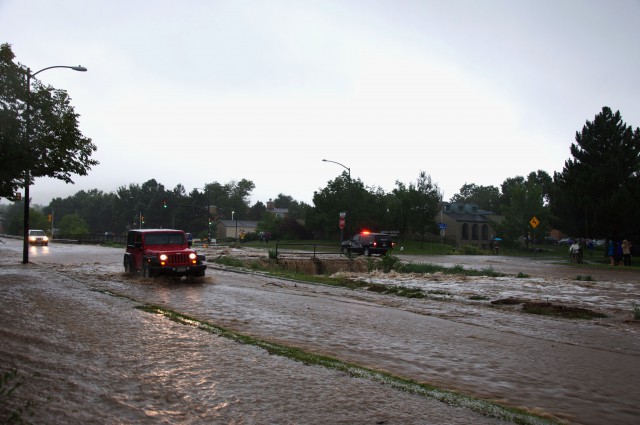
This story is part of Our Road to Recovery, our coverage of the 2013 Boulder County floods.
In Boulder, they say it was a 100-year flood.
Uh, not exactly.
Boulder city officials, U.S. Geological Survey (USGS) officials, and the media have all averred that last week’s flood was a 100-year flood, or as the USGS prefers to call such events these days, a “1 percent annual exceedance probability flood.” (The USGS prefers the latter term, despite its clumsiness, because it makes clear that a 100- year flood is really a flood that has a 1 percent chance of happening in any given year, not a flood that shows
up like clockwork once a century. If a city got particularly unlucky, it
could have hundred-year floods in consecutive years or months, or even a
string of them.)
The claim that Boulder experienced a 100-year flood event appears based on the amount of rain that fell in the city between 6 p.m. on Sept. 11 and 6 p.m. on Sept. 12 — 9.08 inches — which made the period the wettest 24 hours in Boulder since official records began being kept in 1897. (The previous 24-hour precipitation record was 4.80 inches on July 31, 1919.) Last week’s flood might also turn out to be a 100-year event in terms of the amount of rain Boulder received in a single storm, the amount of land flooded, the number of streams that flooded at the same time, or similar measures.
But by one important measure it was not a 100-year flood, and that may be the most crucial “not exactly” in Boulder for, say, the next 100 years.
The most important metric for determining whether a flood is a 100-year flood — the metric used by Boulder and virtually every other city in the country in defining flood plains and fashioning flood plain management policies and emergency response schemes — is the rate of stream flow at the height of the flood, measured in cubic feet per second (cfs).
And by that standard last week’s flood was not a 100-year one, not even close.
The definition of a 100-year flood on Boulder Creek that is used by the City of Boulder and assorted federal and state agencies is a flow of roughly 11,000-13,000 cubic feet per second at a flood’s height, depending on where on the creek the flow is calculated. This figure has been determined by multiple studies of the creek’s hydrology over the last 36 years, the most recent of which was done by Anderson Consulting Engineers, Inc. of Fort Collins, and completed July 31. (The Anderson study calculated the stream flow during a 100-year flood event at 18 locations on Boulder Creek. They ranged from 11,650 cfs at the mouth of Boulder Canyon to 13,300 cfs at the point where Boulder Creek crosses 61st Street.)
Boulder Creek’s maximum flows during last week’s flood were reported to be around 5,000 cfs, both early Thursday after a wall of water entered the creek from Fourmile Canyon and again Thursday evening when a 5,300 cfs flow was measured at 75th Street.
The stream flow during last week’s flood was less than half the flow the city has historically calculated would occur during a 100-year flood. According to the Anderson study, a 5,300 cfs flow last Thursday fell a little short of the estimated minimum flow during a 25-year flood (a flood that has a 4 percent chance of happening in any given year) on Boulder Creek.
If you think last week’s damage was bad, think what might have happened if Boulder Creek was running at 11,500 cfs instead of 5,300 cfs.
This matters, because if public officials and the public at large start thinking that the damage inflicted during last week’s storms is what can be expected to occur during a true 100-year storm, the chances of making bad land use decisions, like allowing major new construction in flood hazard areas, or bad emergency management decisions, like failing to order evacuations of low-lying areas in a timely manner, become much greater.
It also matters because Boulder has a long history of allowing major public and private construction along the creek — even though the risks of doing so have been known since 1894, when Boulder experienced a true 100- year flood (with an estimated peak flow of 13,000 cfs). Boulder’s library and city hall, Boulder Community Hospital’s Foothills campus, Boulder High School, CU married student housing, the CU research campus, the city-county court complex, Ball Research and Corden Pharma are all built in flood hazard areas. Some of these were approved after their builders agreed to take steps like putting up berms or raising the elevation of their sites with fill to get them out of the floodplain to mitigate the flood hazard — which may or may not prove adequate when a real 100-year flood (or larger flood) comes along. In the case of some of the older ones, like Boulder High School and CU’s Newton Court married student housing, the builders chose to blow off the risk.
Actually, compared to what could have happened last week, Boulder was incredibly lucky. The 12.2 inches of rain that fell from Monday to Thursday last week was almost identical to the amount of rain that fell in Big Thompson Canyon during the 1976 flood that killed 144 people. The difference is that Boulder’s 12 inches were spread out over four days, whereas the Big Thompson storm dumped 12 inches into the canyon in a single night — including 7.5 inches that fell in an hour. The single-hour downpour produced a flood that was running at 31,200 cubic feet per second at its height; it’s considered to have been a 500-year flood if memory serves.
There’s no hydrological or meteorological reason why a similar downpour couldn’t have occurred in Boulder Canyon or couldn’t occur there in the future — it’s just the luck of the draw.
If Boulder had gotten two-thirds of last week’s precipitation in an 8-inch-an-hour-long gully washer, the resulting flood on Boulder Creek might have exceeded a 500-year flood on Boulder Creek. Anderson Consulting’s study calculated that a 500-year flood on Boulder Creek would produce a peak flow of 21,000 to 27,200 cubic feet per second. It doesn’t take a lot of imagination to predict the sort of havoc that sort of a flood would cause.
That in turn suggests a simple, common sense approach for future floodplain management in Boulder: Don’t build in it.
Respond: [email protected]
This story is part of Our Road to Recovery, our coverage of the 2013 Boulder County floods.


